Grants
Marine Ecosystem Protection and Regeneration
Reposidonia: Mapping Sea Grass Meadows
€12,500 awarded
Project Status: 2022 – COMPLETED
The AEF is pleased to announce its support through a grant for a project to map critical habitats formed by meadows of Posidonia oceanica in the Argolic Gulf. The project will be carried out by the Greek NGO iSea working together with terraSolutions.
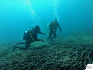
iSea divers and researchers will visit the Argolic Gulf in the spring of 2022 in order to conduct the first ever on-site effort to map meadows of Posidonia oceanica in the region.
The aim of the project is the precise mapping of the seagrass meadows in coastal areas of Spetses and the uninhabited islet of Velopoula. This will be achieved through the use of high-resolution satellite images. The mapping team will visit and identify locations with a high density of seagrasses in order to gather data from the field. This will be then used to train and verify the accuracy of a mapping model that will create a high-resolution map using data from the satellite images.
Posidonia oceanica in the Argolic Gulf
Posidonia oceanica, also known as Neptune grass, is a species of seagrass endemic to the Mediterranean. Meadows of the plant form vital habitats for a wide variety of species, offering breeding grounds and providing shelter to juveniles seeking refuge from predators. Through photosynthesis and trapping layers of sediment, the seagrasses are also able to sequester large quantities of carbon. However, they are under increasing threat from physical damage from boat anchors and fishing, as well as other human activities.
The islands of Spetses and Hydra and the Peloponnesian coast of the Argolic Gulf have seen high levels of touristic development in recent decades, being easily accessible from Athens and other major cities. Yachting tourism in particular has grown in recent years, a trajectory that is likely to continue. This has almost certainly had a direct impact on the local seagrass meadows in the Argolic Gulf which have never been properly mapped and evaluated.
The mapping project will lay the groundwork for additional actions to manage and protect the seagrass meadows. These include raising awareness among visiting sailors and providing them with tools to avoid laying anchor at sensitive sites. The project will also assist in identifying high-priority seagrass meadows in an area where the impacts from human activities are on the rise, aiding in their conservation.
The mapping project may be further expanded in the future to include other areas in the Argolic Gulf, filling key knowledge gaps about these vital ecosystems.
The project will be carried out by iSea working together with terraSolutions and with funding from the Argolic Environment Foundation. It forms part of iSea’s broader Reposidonia campaign with co-funding the Ionian Environment Foundation and KYMA Sea Conservation & Research.